top of page

GIS MAPPING
RESEARCH/INTERNSHIPS

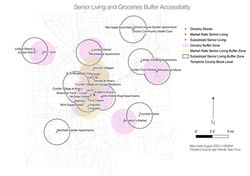
I've worked with NYC District 10's Senator Sanders Office to analyze and create maps for further consultation regarding the digital divide in a COVID era, created maps to analyze pharmacy/grocery proximities with Cornell University's Professor Mildred Warner, and used maps as visual aids in understanding economic policy.

dog_runs
foreignborn
zoning
unemployment
rentburden
parkacces
population
hospitals
green infra
playareas_parks
lab9 map 4
map2
map
nyc areapolice
senior living x grocery
map3l;ab9
lab9map1
senior living x grocery 3
lab10-map1
gaps
senior living x grocery  2
pharmacy x senior living
atlanta crime
medical offices x senior living
lab9map2
lab 5 map 3 tax parcels
map 3
pharmacy x grocery
pharmacy x grocery 2
map 2
updated roads map 4
LAB 5 MAP 2
coastlihnemap
lab 5 map 4
Medical Offices
pantries x grocery
hydrology
final map
LAB 5 MAP 1
subway station buffer
atlanta police station buffer
subway station buffer map final
Policedeptmap
NYCcrimeoverlay
senior living x grovery 2.5

© 2025 Savanna Lim

bottom of page